
Elevation 14,508
Prominence 10,075
Sierra Nevada Range - Inyo National Forest
John Muir Wilderness
We began this journey several months ago while hiking in December. We discussed how cool it would be to get to the highest peak in the lower 48. Go big or go home!!
This mountain has become so popular with people traveling from far away to hike it, they've had to start a lottery system for permits. All of the permit info can be found here.
So, when April came around, we both entered the lottery with multiple dates from July to October. As luck would have it, one of the weekends I chose was picked!! September 29th for 2 nights with camping at Outpost Camp. Woohoo!!

It's amazing that we were chosen because the odds were so against us, especially on our first entrance into the lottery. But we made it and now the journey to the summit begins!
Chris's birthday was shortly after receiving the results, so his birthday box was full of hiking supplies with a theme.... Mount Whitney. We were still months away, but preparing was already on our minds. Books, Maps and we joined several message boards and Facebook pages for Mount Whitney
The months leading up to this hike, we constantly read the forums, Facebook posts and especially the summit reports that people posted every day after they completed their journey.
In the weeks leading up this adventure, we also did some training that I feel is part of what made this a successful summit. About 4 weeks before, we challenged ourselves to see if we could indeed hike continuously above 10,000 ft for 15 hours and cover 18+ miles by hiking 4 peaks around Mt Rose Nevada. 2 weeks ago, we hiked White Mountain Peak to continue to acclimate to 14,000 feet. We gained a lot of confidence after these trips and also learned a lot about what we need to eat, hydration, layers and that even though we had some challenges and illness, we can handle this hike.
With some training under our belts and a wealth of knowledge from all of our resources, we now just have to keep an eye on the weather. I became obsessed with checking the weather! In the weeks leading up to our hike, there has been about 8" of snow, thundershowers, lightning storms and lots of snow and ice on the trails. Thankfully, it also warmed up right after and most of the snow and ice has melted.
This is our weather window for summit day.

Our 3am departure on the 29th is going to be a chilly one. At outpost camp, it's a little warmer than this peak forecast, but only about 10 degrees.
The peak will be 28 degrees and a wind chill to 19!! Brrrr
Now that we know the weather, let the packing begin...
First of all, THE FOOD.
So many options. We figured that we would need about 300 calories after each mile, which also translated to about every 45-60 minutes. Estimating 10 hours on trail, that would be 10-300 calorie snacks! And that's just for Saturday. We also had Friday meals and Sunday meals to prepare as well. I dehydrated watermelon, apples and peaches, bagged trail mix, protein trail cakes, nuts and had a few packages of Shot Bloks for quick energy. I planned on preparing breakfast burritos Saturday morning to take on trail and Chris was going to have Oatmeal. He also brought tortillas with almond butter and honey and some of the same trail mix, nuts and Shot Bloks. We decided to take care of our own food so that we made sure we brought things that would satisfy us, but also things that wouldn't upset either of our stomachs.

We are both bringing our own Bear Vaults since there is so much food. I got mind packed and wow, it's heavy!! One thing I learned on this trip is that the bear vault is bulky and heavy!
Mine weighs 7.2 pounds!!

Here's something else we had to learn about for this trip.
WAG (Waste Alleviation and Gelling) Bag. There are a few things that nobody talks much about when hiking. One is when/where to use the bathroom, dig a cat hole, etc. Because of the sheer volume of people hiking this mountain and the fact that it is a huge mound of granite, human waste can be a huge issue. About 10 years ago it became mandatory that you carry out your own waste. On this trip, what goes up, also comes down. Park services provides each person with a WAG bag and they are dispensed with the permits and included in your fee.

Here's another thing. The thought of carrying your waste in a plastic bag and being smashed in your pack with all of your gear wasn't appealing. I did more research and found several blogs that discuss ways that hikers and climbers deal with their waste. One was to build a "poop tube" with PVC pipes and caps. As great as that sounds, I also know that PVC is heavy. After dealing with the weight of the bear vault, I don't want to add MORE weight with a PVC tube. So I started trying to find other solutions. A Tennis ball plastic container was my first thought, but I don't play tennis and would have to go and buy a package of balls just for the container... So I found a container for Lysol wipes that I had in the bathroom. Transferred the wipes to a ziplock and I now have a Poop Tube for my pack! The wag bag will be rolled up and slipped inside and I now won't worry about it having a blow out in my pack. Ewww. This container is very light and will be thrown out at the end of the trip. a win-win.
We did our final bag checks on Wednesday evening and will both be leaving early from work Thursday to get ready for the 6.5 hour, 340 mile drive to Whitney Portal.

We were so excited to get started and were on the road by 4pm. I had been feeling like a cold was coming on, but I'm thinking positive and hoping it's nothing and by morning I'll be just fine.
We stopped in Bridgeport at Rhino's Bar & Grille for a quick dinner.

Chris had made arrangements to pick up our permits at the Visitor Center in the Night Call box. You have to call a few days in advance and they will leave the permits and wag bags for you. The Box is in this gazebo and they give you the code when you make the reservation.
All the info for picking up permits is found here.

And here they are.... Our permits!!
These permits have to be put on the outside of our packs and visible at all times. You also have to carry your wag bags with you on the trail. We saw Rangers every day on the trail and they also came into our camp and checked out bags and permits. If you're found on trail without either, they will turn you around and can fine you.

With permits in hand, we make our way to the Whitney Campgrounds. We arrived at about midnight. It's a quick stop just to get some sleep. We will head up the mountain in the morning.

There are several campgrounds on the way up to Whitney Portal.
Most are by reservation only and if you didn't grab one, they were all sold out. There were also a few dispersed (walk-in) sites that were very close to the trailhead. There seemed to be quite a few of those still available. Thankfully, Chris made reservations well in advance and we had a cozy spot for the night.

The campgrounds are very pretty. No potable water, but lots of places to filter and we are enjoying toilets for as long as possible because starting tomorrow, it's all about WAG bags... I also have to say these are some of the cleanest vault toilets we've found in a campground.

Not a bad view for a morning wake up. Thanks Leeloo!

We are eager to get going, so we had a quick breakfast and made our way up the hill to the Whitney Portal Store. We will come back here after our hike and pick up a few mementos to commemorate our achievement.

And here it is... The official start of our adventure!! We are "on-on" and heading out on the trail.
The trailhead is at 8,360 feet.

The pallet wall at the trailhead.

They have a scale to weigh your pack. Mine was the heaviest at 46 pounds!! WOW!
Chris's bag weighed in at 44. I know that some of the extra weight is definitely in all the food, but also in the layers. I get cold easily and have multiple layers to try to stay warm. The 5 pounds of hand warmers may be adding to the weight too!! haha

The trail up to outpost camp is very pretty.

It's also a nice, soft granite trail. We have a very rocky hike ahead of us, so we welcome the soft, smooth trail at this point.

There are a few water crossings on this part of the trail too. Earlier in the year, these were completely covered in water and made this part of the trail a challenge.

As we get higher, the rocks begin. The trail is very well maintained, but LOTS of huge steps. Many were 18-20" high. Not so bad going up, but coming down it really gets the knees.

This is another water crossing, it's very long and these logs go all the way across. This has also been under water during the winter/spring. We've timed this one well and these were all crossed with ease.

The Whitney Zone!

The hike up from Whitney Portal is beautiful and often overlooked when people discuss or post about hiking Mount Whitney

The meadows along the Whitney trail.

Another water crossing, right before we get to camp.

And 4 miles from the trailhead is our home for the next couple of nights. Outpost camp! There are plenty of spaces to camp here, fresh water sources and privacy spots to handle your........um....business.

We quickly chose a campsite and set up camp along side the trail. There are more private spots available but we wanted to be near trail to interact with all our fellow adventurers.
Today is all about resting and continuing to acclimate.
Outpost Camp is at 10,400 feet. We chose Outpost over trail camp because it was at a lower elevation and also had some coverage from the weather. Although it will add 4 miles to the overall summit day, sleep and a little protection is more what we were interested in.

The views from camp are also amazing. In the very left of this frame is the beginning of our hike. It's straight up, but traverses the side of the mountain. Can't wait to get started! Tomorrow...

And as luck would have it, Chris found this quarter at camp!! I have no idea how he saw it tucked into the sand, but here it is... A 1991 quarter that has seen many a day here at Outpost camp. We call found coins, pennies from heaven and we made a tradition of leaving them on peaks while making a wish. It will be traveling with us and we will be leaving this at the peak.

After a 2am wakeup, breakfast which consisted of trail protein cakes for me and instant oatmeal for Chris, we are packed and excited to hit the trail. We were on trail by 3:15am.
It's chilly, but about 40 degrees with light winds. It will be getting colder as we get higher.

Navigating the trail in the dark was pretty easy with headlamps. There were a few times were we could come across a large rock slab and not sure of where the trail was, but it wouldn't take long to figure out where the trail picked up on the other side.

A little hard to see, but the specs of lights ahead of us are other hikes. It looked like fireflies or stars at night as others traverse the mountain ahead of us. It's very cool to be experiencing this along with all of the other hikers that are out to conquer this mountain in the wee hours of the morning.

This water crossing has been a topic of discussion on many other summit posts. Several have slipped on these rocks and had to step into the water. They then had to turn around and unable to summit. It's far too cold to continue after you get wet. We were able to carefully navigate it and could breathe a sigh of relief on the other side.

Taking a quick stop to hydrate and eat. This tree had a big heart carved in it too! ♥
It also shows my shirt. Chris had these shirts made for this adventure. Our GottaGetGone logo and it says Mount Whitney 2017 under it. So cool!!

Our first bit of snow/ice on the trail. We are nearing trail camp and the bottom of the switchbacks. This is the point at which I had to pause and say, "We are really doing this!". The enormity of this is hitting me. It almost brought me to tears a couple of times since this is something I've really wanted to do for some time. So happy to be sharing it with someone so special to me. Wouldn't have wanted to do this any other way.

The sun is starting to appear. We are at about switchback 10 when this begins. A welcome sight as now we can really see what's ahead.

At about switchback 30, the windows are showing themselves. The camera really lit this up, but we are still hiking in the ambient light of the early morning sun.

The lake at trail camp is below, the sun is rising in the background and we are tackling the switchbacks!

The cable section. There tends to be snow and ice here, but we found this easy to navigate around the ice that had formed closer to the mountain. You did have to walk along the right edge, but it was easily passable.

The windows are glowing as the sun starts to peak over the mountains.

Switchbacks anyone?
We hear so much about these switchbacks, but I actually didn't mind them at all. They made this very steep portion of the climb very tolerable. At least on the way up.

More switchbacks!

This really shows the steps. This is what this trail is all about. Large rocky steps. It definitely makes the climb up much easier. We are counting switchbacks and calling out numbers as we go. It made this much less monotonous, but instead of the "99 switchbacks" that we've heard to much about, we counted 101. There is some controversy about the number of switchbacks. Some say it's 99, others say it's 97. One thing we do know if that it's not 101!! haha... We will have to count them again on the way down. The early morning darkness may have caused us to count some turns as switchbacks.

And at the top of the switchbacks is Trail crest! 13,600 feet! We've made it to the top of the portion of the trail. What we know now is that we have to go back down 300 feet, to go back up the back side of Whitney. This downhill section is VERY rocky.

Once we get down the trail, we begin the final approach. This 1.9 mile section is said to be the hardest part of the hike. It's also very cold. The area through the windows is a wind tunnel and the wind chill is increasing. 19 degrees is chilly! Both are faces were red from being wind swept and exposed to the freezing temps.

The trail meanders it's way along the edge. You can't see it here, but just to the left of the point in the picture is the very top of the hut at the top. It's far, far away...

The rocky trail and steps as it hugs the mountain side. Lots of rock and slide activity in these areas. Those that have said this is the hardest part of the trail were correct. The 1.9 section after trail crest is very rocky, slow going and because we are now in the shade, it's very cold and windy.

We continue to move along the trail at a decent pace. There isn't much gain or loss at this point.

Another view of the trail ahead.

Guitar Lake is really shaped like a guitar...
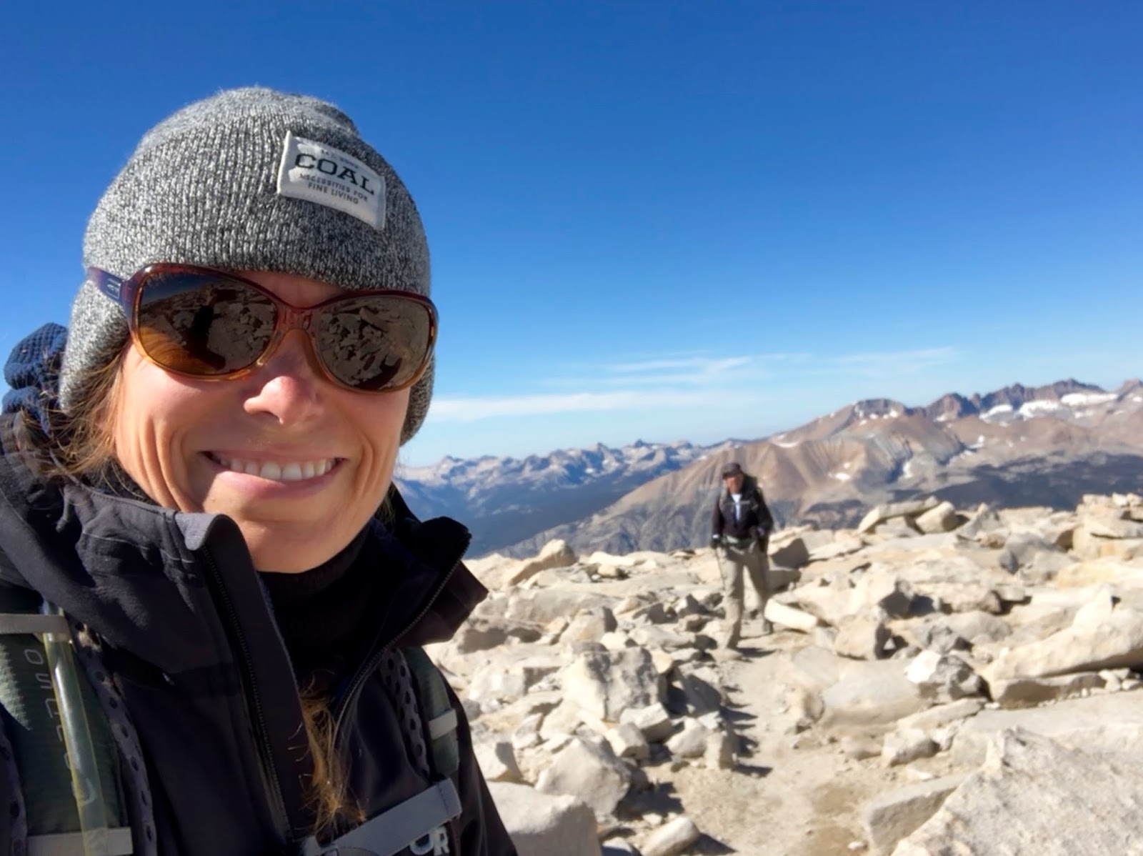
And this is it, our final approach up the trail to the peak! I have felt great this entire ascent. I really feel acclimated and walking at a pace that keeps me feeling like I have my breathe and stamina. Chris is doing great, but feeling some of the effects of the altitude (After having a mild bout of AMS while climbing White Mountain, I knew that I needed to take it nice and easy after we hit 13,000 feet. I felt good all the way up without any dizziness or headaches, but I was surely breathing heavy and took frequent breaks on the final summit push to catch my breath...that really seemed to helped in my summit bid....Chris) So, we take things slow and continue to make our way closer.

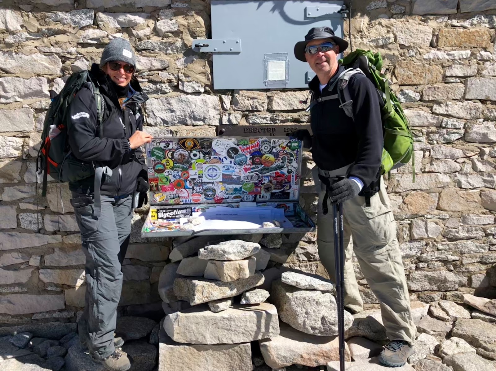
And there it is! The Mount Whitney Summit Shelter!! This shelter was built in 1909 and still stands tall and strong to this day. Although this is called a shelter, it's actually recommended to stay away from it during a storm as it is not a good place to shelter from lighting. But it's a landmark and shows us that we are almost there!!

And we did it!! We climbed to the highest summit in the continguous United States.
Mount Whitney 14,508ft.

The views are amazing in every direction.


We placed a sticker and signed the official summit register.

We spend about 40 minutes at the summit. Looking at all of the views and we sat behind a wind break for a quick snack. We know that getting to the summit is only half the hike. We have a long way back to camp and need to get back on trail. As we start making our way back down, I ran out of water. We hadn't even made it to the switchbacks. Our plan this morning to filter before we headed up from trail camp didn't get as scheduled. We weren't quite sure where the final water source was and we missed it. I quickly ran through my 3 liters I was carrying and now have no water until we get back to trail camp. I was able to share some of what Chris had, but being tired and without water was starting to wear on me. As we make our way back towards Trail Crest, my muscles were starting to shut down. The climb up the large stairs was actually fine, I made quick work of them. The climbing DOWN was much harder. My muscles were tired and my knees starting feeling the brunt of each step. I was crashing. We stopped near trail crest and my quads were quivering. Something I've never experienced. The trip down was going to be a difficult one.

A view of the cables as we descend. I am going very, very slow. Leaning on trekking poles at every step down and having to take breaks to let my knees rest. But we are making our way down the switchbacks. The lake at trail camp is below. It's still a loooong way from us.

And finally we made it to trail camp! Water and electrolytes are going in and we are taking a much needed rest to recharge. We are about 2 miles and a 2,000 ft descent from outpost camp, so we can't rest for too long. But I'm needing this break.

After some water and snacks, we continue towards outpost camp.

More rocks, more steps, it's slow, but we continue to make our way down.


We stopped at Trailside Meadow to filter more water. We are both now carrying our MSR Trailshot water filters in our packs. These are the best little filters ever! I use my larger MSR Guardian for camp as it filters so fast and also filters out viruses, but on trail, these trail shots are awesome!


This water crossing is a little easier to navigate during the daylight hours. Thankfully, we crossed over it easily in both directions. No wet feet!


A most welcome sight! Down in between the trees is our tent. Yay! We are almost there. So glad to be nearing the end, I am totally exhausted. Chris seems to be tired, but doing ok.

We arrived back at camp as the sun is starting to set. The way down was slower than the way up. A total of 15 hours. My body just didn't cooperate with me and the lack of water paired with all of the large steps down, I was exhausted. We started to unpack gear to make some dinner and I was overcome with nausea and exhaustion. I had to just lay down in the tent. Chris continued to button down camp for the night and found me laying in the tent with my feet hanging outside, boots still on. I was just too tired to take them off and get all the way in...
I was beginning to get worried that this was AMS and although I may have needed to get to a lower elevation, physically I would not have been able to. That added to a bit of the stress level for me, I've never found myself in a position like this. Thankfully after resting for a while, the headache and nausea began to ease. I was able to drink more water during the night and by morning, felt pretty good.

The next morning the sun sets our view all aglow as we have breakfast.

These aren't the prettiest, but we had pancakes at camp before we break camp and set out to leave Mount Whitney.

All packed up and ready to head out.

The trail from Outpost camp to the trailhead is beautiful.

Views of Lone Pine Lake.

The sun peaking over the mountain.

More switchbacks! But after a good rest, we both have a little pep in our step so we are making good time.

The trail meanders around the large boulders heading down into the valley.

Looking down towards Lone Pine


As we are driving back down the road heading towards Lone Pine, our view looking back is of Mount Whitney in all her glory. Even with a few setbacks, this was an amazing adventure.

The traditional meal after a summit is to have a burger and beer at The Whitney Portal Store. Due to water contamination issues, there is no food being prepared there for hikers. I asked Chris to choose a lucky number and he said "3". So, we ate at the third place we saw once we hit Lone Pine, we were both starving!! Thankfully it was the awesome Frosty Chalet! I got a chance to speak to the owner for a few minutes and he had always wanted to climb Whitney as well. He's had to remove it after some health issues, but he likes hearing the stories of those that come down the mountain. When I asked him about the size of the burgers, he said that In & Out Burgers were modeled after his, so they were similar in size.

We both ordered the cheeseburger, with everything! And some onion rings.
OMG, just what was needed after a long hike.
I was craving a hot fudge sundae, but they were out of hot fudge. The owner recommended the swirl cone, dipped in peanut butter. Yes! We ordered one in a cup and split it. Wow, that was yummy!

We have driven through Bishop 4 times now heading to and from our adventures over the last month. It's a cool town and we wanted to stop at this brewery to check it out.
Mountain Rambler Brewery didn't disappoint. The menu looked amazing and had we not eaten in Lone Pine, we would have eaten here. We ordered a flight and sampled them each as well as a taste a cider they had on tap. We also bought a few glasses and a sticker. A cool place and we would come here again if in the area.

We drove home to cotton candy skies and arrived back around 7:30pm in Placerville. We stopped at Bricks for another quick bite to eat and then home.
It's been almost a year in the works. Lots of research, planning, training and excitement. The adventure is over, but we have so many memories and a sense of accomplishment from this adventure. It's an amazing trip.

Our Summit as recorded via Strava app for iPhone 8
Comments
Post a Comment